Historical England aerial pictures show Derby's past and present
- Published

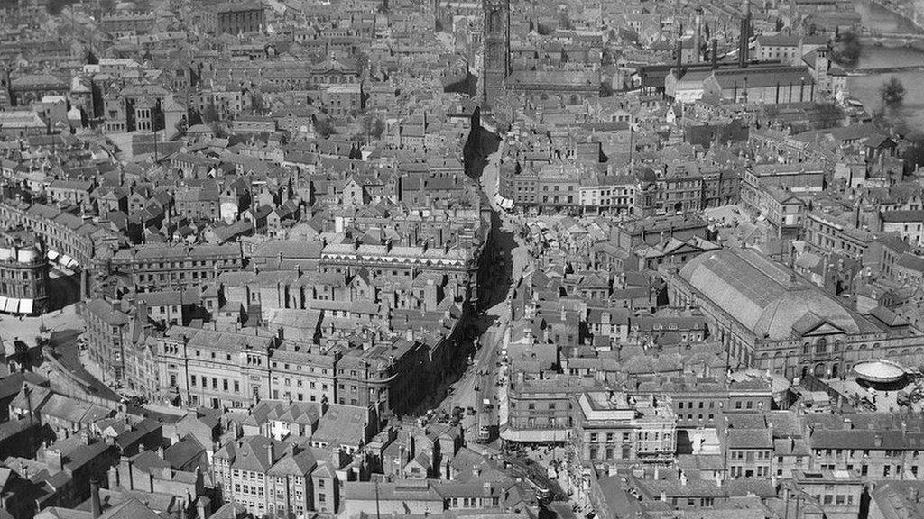
A view of Derby city centre, taken in 1921
Newly-released aerial photographs from Historic England illustrate how a city centre has changed over the course of a century.
While some landmark sites in Derby city centre - such as its cathedral and the 300-year-old Grade II listed Silk Mill (now the Museum of Making) remain largely unchanged, others - most notably the city's Assembly Rooms and surroundings have altered beyond recognition.
Since the picture above was taken, in 1921, the 18th-Century Assembly Rooms have been hit by fire in both 1963 and - following a rebuild - in 2014. The venue is currently closed.
A view of the same area 100 years later
The century-old photograph shows a view of the city looking up the Corn Market and Iron Gate.
It was taken at a very low level and Historic England said flying at that height is not allowed today.
The Wardwick area retains a familiar look
The organisation's allows users to search and explore an online map showing aerial photographs of England over the past 100 years, allowing people to compare and contrast different views of local towns and cities.
A picture taken of the same area in 2021, shows work ongoing on the market hall which is currently undergoing a 拢35m renovation and is expected to reopen in 2024.
In the background, the A601 bridge can be seen coming over the River Derwent.
Factories along the River Derwent in 1952
Another much-changed view of the River Derwent can be seen in this image, from 1952, from the City Road angle, showing factory sites that have long since disappeared.
Derby's former Greyhound Stadium, which has now been redeveloped
Another view from 1952, shows the site of Derby's Greyhound Stadium. The stadium closed in the 1980s and the site has now been redeveloped.
A photograph from 1931 shows the old Derby City General Hospital shortly after it was built, amid rural surroundings. The Royal Derby Hospital, which was officially opened in 2010, now occupies the site.
The site of Royal Derby Hospital was previously occupied by the old City General - largely surrounded by fields
Away from the city, there are also plenty of interesting views of landmarks both urban and rural.
A more modern view of Mam Tor, in the Peak District, picks out evidence of circular hut platforms which, Historic England's excavations suggest, were part of a Bronze Age settlement.
More than 400,000 images from 1919 to the present day have been added to Historic England's online tool, covering nearly 30% - about 15,000 sq miles - of England, allowing people access to the archive.
Archaeological features on Mam Tor suggest the presence of a Bronze Age settlement
There is a view of Shirebrook Colliery in 1926.
The colliery was one of the last to close in that area when it ceased production in 1993 and is now the home of Sports Direct's head office.
The archive has proved hugely popular - thanks to interest in shared local heritage, of which the site of Shirebrook Colliery is a classic example
Matthew Oakey, interim national aerial investigation and mapping manager, said: "Around 300,000 of the photographs were taken by Historic England's own flying programme. We have aerial archaeologists flying throughout the year, photographing landscapes both urban and rural and recording and discovering new archaeological sites.
"A large number of photographs were taken by the RAF during and after World War Two for surveying and planning purposes. We also have a number of photographs taken by a company called Aerofilms Ltd, which mostly span the period from the 1920s to the 1960s and provide a fascinating snapshot of the interwar years.
"They record big cities that were heavily bombed and you can see huge amounts of landscape change."
This view of Derby shows the cattle market on the left
He added the archive had proved hugely popular since its launch.
"On day one, we had over 100,000 visits," he said. "I think everybody has a very natural curiosity about their heritage, particularly their local heritage. Being able to view where you live in this way - maybe even your own house - is fascinating."
Follow 成人快手 East Midlands on , , or . Send your story ideas to eastmidsnews@bbc.co.uk.